


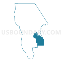
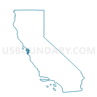
Voting District 30440, San Mateo County, California
About
Outline

Summary
| Unique Area Identifier | 542926 |
| Name | Voting District 30440 |
| County | San Mateo County |
| State | California |
| Area (square miles) | 51.45 |
| Land Area (square miles) | 51.42 |
| Water Area (square miles) | 0.03 |
| % of Land Area | 99.94 |
| % of Water Area | 0.06 |
| Latitude of the Internal Point | 37.28567710 |
| Longtitude of the Internal Point | -122.22416520 |
Maps

Graphs
Select a template below for downloading or customizing gragh for Voting District 30440, San Mateo County, California


Neighbors
Neighoring Voting District (by Name) Neighboring Voting District on the Map
- Voting District 30420, San Mateo County, CA
- Voting District 30445, San Mateo County, CA
- Voting District 30455, San Mateo County, CA
- Voting District 30515, San Mateo County, CA
- Voting District 30520, San Mateo County, CA
- Voting District 30525, San Mateo County, CA
- Voting District 30540, San Mateo County, CA
- Voting District 30610, San Mateo County, CA
- Voting District 30630, San Mateo County, CA
- Voting District 30730, Santa Cruz County, CA
- Voting District 51135, Santa Cruz County, CA
- Voting District 51180, Santa Cruz County, CA
- Voting District 53060, Santa Clara County, CA
- Voting District 53095, Santa Clara County, CA
- Voting District 53100, Santa Clara County, CA
- Voting District 53105, Santa Clara County, CA
- Voting District 53110, Santa Clara County, CA
- Voting District 53115, Santa Clara County, CA
Top 10 Neighboring County Subdivision (by Population) Neighboring County Subdivision on the Map
- San Mateo CCD, San Mateo County, CA (383,442)
- Half Moon Bay CCD, San Mateo County, CA (28,894)
- San Lorenzo Valley CCD, Santa Cruz County, CA (23,195)
- West Santa Clara CCD, Santa Clara County, CA (7,529)
- West Santa Cruz CCD, Santa Cruz County, CA (4,283)
Top 10 Neighboring Place (by Population) Neighboring Place on the Map
- Palo Alto city, CA (64,403)
- Woodside town, CA (5,287)
- Portola Valley town, CA (4,353)
- La Honda CDP, CA (928)
Top 10 Neighboring Elementary School District (by Population) Neighboring Elementary School District on the Map
- Cupertino Union Elementary School District, CA (138,600)
- Los Altos Elementary School District, CA (40,653)
- Portola Valley Elementary School District, CA (6,479)
- Lakeside Joint Elementary School District, CA (2,632)
Top 10 Neighboring Secondary School District (by Population) Neighboring Secondary School District on the Map
- Sequoia Union High School District, CA (243,514)
- Fremont Union High School District, CA (223,745)
- Mountain View-Los Altos Union School District, CA (106,288)
- Los Gatos-Saratoga Joint Union School District, CA (53,209)
Top 10 Neighboring Unified School District (by Population) Neighboring Unified School District on the Map
- Cabrillo Unified School District, CA (25,434)
- San Lorenzo Valley Unified School District, CA (23,877)
- La Honda-Pescadero Unified School District, CA (3,464)
Top 10 Neighboring State Legislative District Lower Chamber (by Population) Neighboring State Legislative District Lower Chamber on the Map
- Assembly District 19, CA (433,645)
- Assembly District 21, CA (432,366)
- Assembly District 27, CA (424,862)
Top 10 Neighboring State Legislative District Upper Chamber (by Population) Neighboring State Legislative District Upper Chamber on the Map
Top 10 Neighboring 111th Congressional District (by Population) Neighboring 111th Congressional District on the Map
Top 10 Neighboring Census Tract (by Population) Neighboring Census Tract on the Map
- Census Tract 6132, San Mateo County, CA (6,494)
- Census Tract 1205, Santa Cruz County, CA (5,687)
- Census Tract 1202, Santa Cruz County, CA (4,283)
- Census Tract 6138, San Mateo County, CA (4,005)
- Census Tract 6134, San Mateo County, CA (3,093)
- Census Tract 5117.07, Santa Clara County, CA (3,009)
Top 10 Neighboring 5-Digit ZIP Code Tabulation Area (by Population) Neighboring 5-Digit ZIP Code Tabulation Area on the Map
- 94062, CA (25,876)
- 95033, CA (9,372)
- 95006, CA (8,979)
- 94028, CA (6,534)
- 94020, CA (1,559)
- 94060, CA (1,554)
- 94074, CA (214)
- 94021, CA (192)